 Bicycling.com the web front end to the world’s highest-circulation bike magazine has for years featured a nifty resource for cyclists, a tool that allows anyone with (or without) a GPS to create maps and turn sheets that can be downloaded by any other rider.
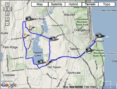
The Rides section of the site is the location of all the GPS goodness, and it’s just gotten a much-needed overhaul to the engine used to create maps and turn-by-turn directions. (Full disclosure: I am a contributor to the Rides section, which makes me expertly aware of how frustrating the old system was.)
The new system creates a “follow-the-streets” route planning system that will now automatically generate turn-sheets on the fly. The tool builds a route map and elevation profile as well.
They’ve also added the ability to upload geocoded images from a GPS capable camera, which then automatically links the photos to the correct location on the route map. In the last iteration of the planning software, it was necessary to manually place images where you thought they should go.
The free resource is particularly great for people looking for routes in areas they’re visiting, or for anyone who wants to create turn sheets for anything from a trip to the local bodega up to a multi-day event ride. If you’ve got a GPS unit you can download any ride on the site right into your device.
…We're riding townies, adventure, and mountain bikes. Find recommendations on our store page. As Amazon Associates we earn from qualifying purchases.